Graduate Students Map Tanzanian Infrastructure Data
Tanzania is a land recognized for Serengeti National Park, snow-covered peaks on Mount Kilimanjaro, the Maasai tribe, and the gleaming beaches of Zanzibar. But for 16 graduate students in Southern Adventist University’s Global Community Development program, it will be best remembered as a life-changing classroom where they learned the art of transformation development through participatory planning, mobilization, and evaluation.
 The seeds of these life-changing moments were planted in 2013 when Southern began
offering a Masters of Science in Global Community Development. Designed by Professor Sharon Pittman, the hands-on degree emphasizes both one-on-one
interactions and cutting edge technology such as geographic information systems (GIS), the most powerful and advanced mapping technology on the market.
“GIS lets us visualize, question, analyze, interpret, and understand data to reveal relationships, patterns, and trends,” said Mike Ruth, a consultant for ESRI Professional Services.
Some of Southern’s students in Tanzania had the opportunity to work with World Vision staff members collecting basic human infrastructure data using GIS while visiting more than a dozen villages. In less than three days, they helped map elementary schools, health centers, roads, and water sources. Community leaders and non-government organizations will now be able to use this information to better plan how to improve services for villagers.
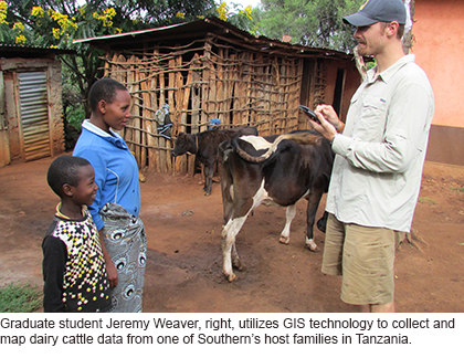
The goal of this training was to replicate the process in nearly 70 other sites within the country. Jeremy Weaver, one of Southern’s graduate students, used GIS technology to head a research project that mapped the impact of improved access to dairy cattle on rural Tanzanian families.
“We collected information quicker and so much more effectively,” Weaver said. “We were also able to capture pictures of the research with the tablets and map areas that have never been mapped before. It was my favorite part of the bush learning experience.”